Tropical Storm Senyar – Latest Weather Alerts & Countries Involved
Tropical Storm Senyar is now in the spotlight because this unusual weather phenomenon brought heavy rain, strong winds and violent sea waves in several areas. This rare incident in the Malacca Strait raises concerns about public safety. To obtain accurate and authentic information, the public is advised to refer to MetMalaysia’s latest alert via www.met.gov.mymyWeather app, or hotline 1-300-22-1638. You can also follow the latest weather, rain and storms via the website
Tropical Storm Senyar has weakened and was downgraded to a low-pressure weather system.
The public is advised to always be alert and follow the latest weather information, forecasts and warnings via the MET Malaysia website, myCuaca application, official social media and hotline 1-300-22-1638.

What is Senyar Tropical Storm
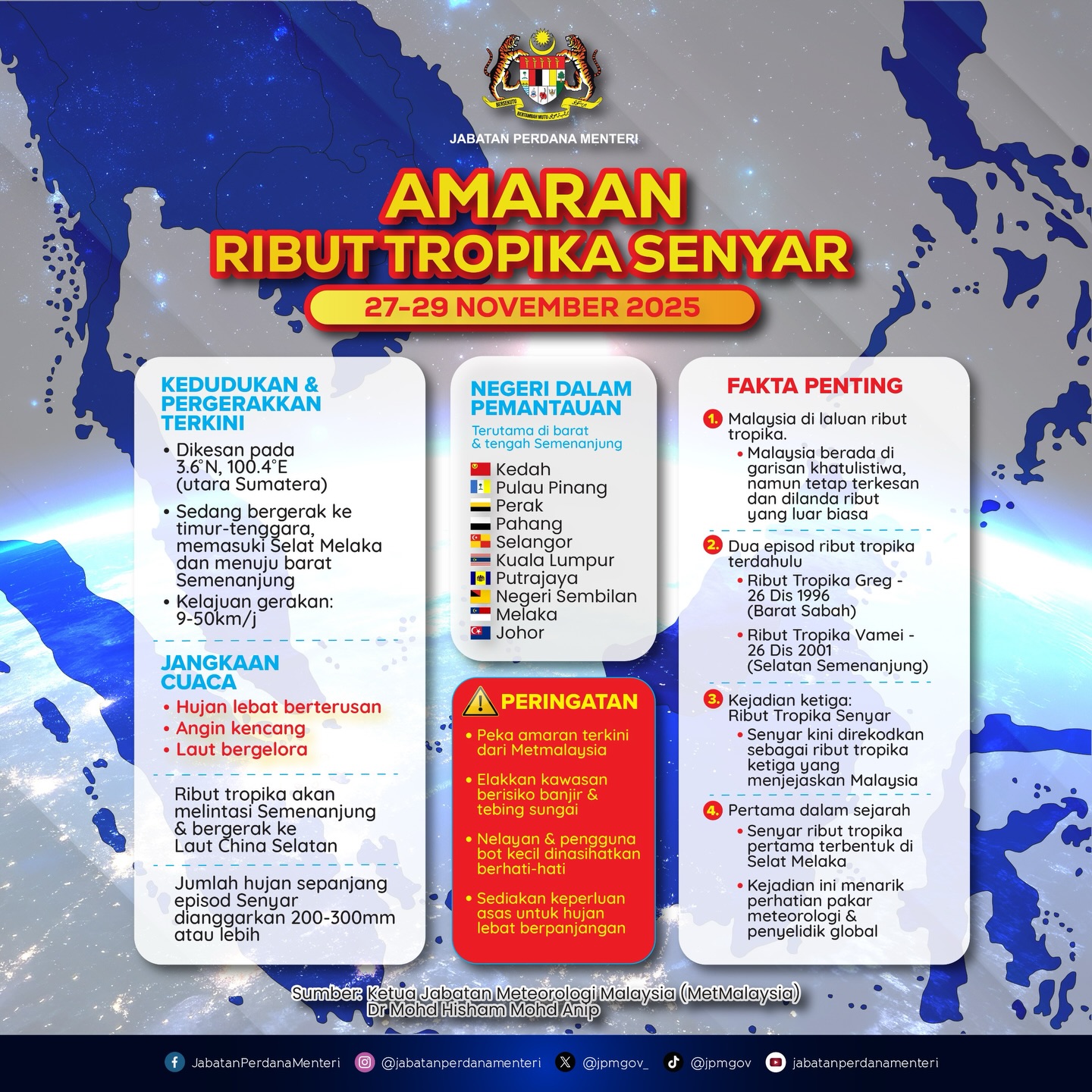
Tropical Storm Senyar is an unusual weather phenomenon that is currently attracting a lot of attention because of its appearance in an area that rarely produces such storm systems.
This storm threatens to have a significant impact on Peninsular Malaysia through continued heavy rain, strong winds and poor sea conditions.
What makes Tropical Storm Senyar so special is the location of its formation in the Malacca Strait, an area near the Equator that usually does not have eddies or whirlpools. Coriolis effect one strong enough to produce a mature, long-lasting tropical storm.
The formation of this storm is considered historic because such events are very rare.
In fact, a similar phenomenon was last recorded in 2001 when Typhoon Vamei formed in the nearby area, making Senyar a significant event in the world of modern meteorology. Because of its uniqueness, this storm is now the focus of weather experts around the world.
Tropical Storm Senyar began developing from a low pressure system hovering over the Malacca Strait since November 21, before gradually gaining strength. The strength of these storms depends greatly on the sea surface temperature in the region.
The warmer the sea surface, the more energy and water vapor the storm system can absorb, increasing the intensity of rain, wind speed and the potential for turbulence it causes.

Heavy and Heavy Rain Warning
With the movement of Tropical Storm Senyar, MetMalaysia has issued a Continuous Rain Warning as well as a Strong Wind and Rough Sea Warning for nine states and two Federal Territories. This warning is valid from 27 to 29 November 2025.
The Sustained Severe Rain Warning (Orange) covers the following areas:
- Penang Island
- Silver
- Selangor
- Kuala Lumpur and Putrajaya
- Kedah (Kulim and Kota Baru)
- Pahang (Cameron Plateau, Lipis, Raub and Bentong)
In India, the India Meteorological Department (IMD) also issued a heavy rain warning in several Tamil Nadu districts including Rameswaram, leading to schools being closed as a safety measure.
People, especially those living in low-lying areas and maritime communities, are advised to be more alert because this storm can change direction and strengthen in a short time.

LATEST: Weather & Flood Warnings
Tropical Depression (b) was detected at 4.0° N and 104.0° E, estimated to be moving towards the Northeast at a speed of 5 km/h and can reach a maximum wind speed of up to 56 km/h. These conditions can cause continuous heavy rain, strong winds and large sea waves in the South China Sea.
The distance of the tropical depression from the nearest city is around 81 kilometers to the northeast of Kuantan, Pahang and impacts the coastal area between Pahang and Terengganu.
The depression is expected to disappear from Malaysia and its impact will not be as severe as Tropical Storm Senyar.
Based on Berita Harian reports, Tropical Storm Senyar is no longer in Malaysia and the only remaining impact is rain, said the Director General of the Malaysian Meteorological Department (MetMalaysia), Dr Mohd Hisham Mohd Anip.
However, the public is advised to prepare for MTL heavy rain episodes by always being aware of the information, advisories, weather forecasts and weather warnings issued by MET Malaysia via the website www.met.gov.my, the myCuaca mobile application, official social media and the MET Malaysia hotline 1-300-22-1638.

The public can also check LIVE via the website
MetMalaysia Senyar Tropical Storm Media Conference
Security Measures
- Avoid Maritime Activities: Stop all activities on the beach and sea because sea conditions are expected to be hostile and very risky, especially for boats and small vessels.
- Flood Preparedness: If you live in the lowlands or near a river, make sure you are ready to move at any time. Find out the location of the nearest temporary evacuation center.
- Follow Official Information: Always refer to the latest warnings and developments from MetMalaysia via the website www.met.gov.my, myCuaca application, or hotline 1-300-22-1638 to ensure the information received is accurate and authentic.
Download the myWeather App
Given the unpredictability of Tropical Storm Senyar, it is important to obtain fast and accurate weather information.
Download the myWeather app on Google Play or the App Store to receive the latest alerts, radar images and important info right on your phone

Tropical Storm Senyar FAQ
Tropical Storm Senyar was a strong storm system that formed in the Strait of Malacca, a very rare event. This causes continuous heavy rain, strong winds, and violent sea waves.
The Strait of Malacca is located close to the Equator, and this region usually does not have enough whirlpool (Coriolis) strength to form tropical storms. That is why incidents like Senyar are very rare.
Yes. An almost similar event occurred in 2001 with the formation of Typhoon Vamei, also in the area near the Malacca Strait.
The main risks faced are heavy rain, flash floods, strong winds, fallen trees, landslides and poor sea conditions which endanger boats and small vessels.
Areas receiving continuous rain warnings include Penang, Perak, Selangor, Kuala Lumpur, Putrajaya, several areas of Kedah, as well as several districts in Pahang.
A weather warning was issued November 27 to 29, 2025, but the impact may change depending on the direction and strength of the storm over time.
The strength of these storms depends on sea surface temperature. More pana
Get official info via MetMalaysia, myCueca app, media releases, or the official Malaysian Meteorological Department platform. Don’t rely on rumors.
News
Berita
News Flash
Blog
Technology
Sports
Sport
Football
Tips
Finance
Berita Terkini
Berita Terbaru
Berita Kekinian
News
Berita Terkini
Olahraga
Pasang Internet Myrepublic
Jasa Import China
Jasa Import Door to Door